Translate

Thursday, August 18, 2022

Struggling to Get Out of the House

Three weeks ago, I left on my usual yearly road trip. I wanted to leave on Monday or Tuesday of that week, but it wasn't until Wednesday that I finally could get myself together enough to head out. Even then, I left the house so late in the day that I only made it to western Maryland before calling it a night at Spring Gap Campground along the C&O Canal Towpath. 

Depression sucks like that. I had the same issues last year as well. 

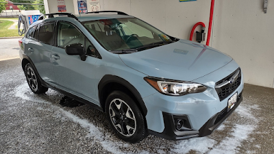
I'd changed the oil the day before in the Crosstrek, and I actually started the trip with a quick stop at the local grocery market and the nearby carwash. 

Me demonstrating the proper way to pour oil so that it doesn't slop all over the place. 

My driving companions for the first week and a half

Fresh and clean!

Since I had a late start, I knew I wasn't going to get super far on the trip and made the reservation at Spring Gap before I left the house. Campsite 1 was reserved for the whole week, and everything else was open. I opted for site 5 to give whoever it was at 1 plenty of space. 

I rolled into the campground around 5:30PM and set up my little tent. For those new to my adventures, this is a "Rhinowolf" tent which I bought via Kickstarter a few years ago; they have since apparently gone out of business. Anyway, one of the selling points for this tent was that single tents could be zipped together. So for the first part of the road trip, you'll see my green single tent, and after Pat joins me, you'll see his blue tent zipped together with my green one. 

My campsite at Spring Gap

As I put up my tent and contemplated what to do for dinner, I did notice that site 1 was very occupied; there was at least one family there with at least two dogs. Everyone (including the dogs) was super friendly, and the kids were kind of goofy and totally into fishing for catfish. A group of cyclists came by while I was settling in and set up in the group camping area at the "end" of the campground. And, in site 3 there was a small pop-up tent and a couple of chairs, but no one else around. 

I decided to wander up the towpath;"up" the towpath always means "towards Cumberland" to me for some reason, while "down" the towpath is "towards Georgetown. I'd last been in this area almost a year ago to the day when I camped here on the first night of my 2021 road trip. No surprise that there were things to see. 

Ruins of bridges are somewhat frequent along the towpath. It's not clear if this was for a train crossing or a road (automobile) crossing

At first I was like, "Yay! A turtle!" and then I was like, "OMG, it's dead," and I was very sad. There was no evidence of trauma to the shell.

Storms have been fairly frequent and brought down a lot of trees in Western Maryland this spring and summer

Lock 72. There are three more locks upstream of this; they are the last three locks on the canal. 

Sunset on the Potomac River at the Spring Gap boat ramp

I didn't bring any wood with me, and it was warm enough I didn't really want to start a fire anyway. Around 8:45, I checked my phone's battery and service levels because it was getting close to #ParkChat time. There's nothing like participating in #ParkChat while being in a park! 🤣

Some foreshadowing occurred during the #ParkChat conversation....

And then just after 10PM, it was all done. I was tired of trying to keep the mosquitoes at bay (the repellant and the Thermacell can only do so much), so I retired to the tent. 

Sadly, around midnight, the mysterious campers at site 3 showed up, lights ablazing directly towards my tent. They were loud. They were shining lights every which way. They were clearly drunk. It was Camp Groinia all over again, minus the lighter fluid shots and 30 degree weather. With the National Park Service short staffed, plus knowing that rangers on the 184.5 mile towpath are often spaced quite far apart, I just gritted my teeth, put my good ear to the pillow and tried to ignore it. 

I have to admit though that I, the cyclists at the group campsite and the family(ies?) at site 1 made absolutely zero effort to be quiet as dawn broke. The hungover jerkwads were clearly struggling as the rest of us did our morning things with just an extra touch of noise. 

Carolina horsenettle

From the campground, I headed into Cumberland to poke around at the very end of the towpath and beginning of the Great Allegheny Passage (GAP) trail. The visitor center was closed, so I just wandered around and looked at the railroad cars and caboose that were there. I was testing my ability to figure out when they were built, something I was taught years ago when visiting the Western Maryland Railway Museum in Union Bridge. 

There should be something that says "BLT" with numbers for the month and year, but evidently these are repaints.
 

The trucks have the manufacturing date built into them. These are from January 1957.

Pat had been talking about maybe getting tickets to a train ride out of Durango, CO as part of the road trip, so maybe that's why I stopped here. I do know that I would like to do one of the Western Maryland Scenic Railroad trips some time. 

Western Maryland Scenic Railroad Depot

I headed out from Cumberland with no real plan in mind. After tossing around some ideas in my head, I decided to go to Cuyahoga Valley National Park, since it had been a few years and it wasn't all that far away. Waze took me off I-68 and up to the Pennsylvania Turnpike, joining the turnpike from an area where Pat and I had stopped on the way out to Detroit in the spring. 

I rolled into the Boston Mill Visitor Center parking, parked next to a cool gray khaki Crosstrek twin, and headed towards the visitor center when I saw a group of people next to a sign that said "Citizen Science." I remarked, "That's cool! I need to do more of that with my students," and next thing I know, they invited me to join them. It was a group of rangers and park employees/volunteers who were looking at the pollinators in the areas around the visitor center over a few weeks time. We started by looking at the different types of flowering plants we saw, and using iNaturalist to identify them as needed. We also estimated what percentage of the surveyed area was covered with each type of plant. Then we went back and started looking for pollinators, and again, used iNaturalist to identify them. We also added our findings to a group on iNaturalist (that's the citizen science part!), to help with the documentation of which pollinators were found with which type of flower. 

I totally want to do something like this with my students this year!

Don't you park next to your car-twin when you can? 


Ranger Chuck is the brains behind this citizen science project

It wasn't always clear if something was a pollinator or just happened to be in the flower

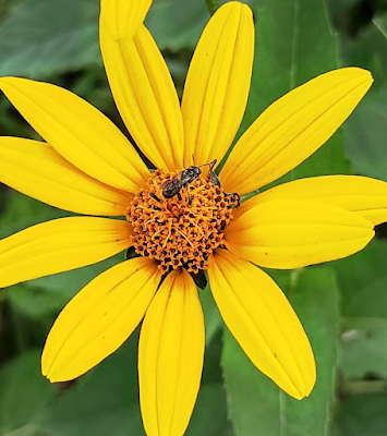
This is a pollinator, on red clover

Wild carrot (Queen Anne's lace) was one of the predominant flowering plants in the area we surveyed

After my work-related diversion, it was suggested to me that the Ledges Trail would be a literally cool place to visit for some hiking. With the tall trees, hidden springs and small caves, a cool breeze was present during much of the trek around the ledges area. 

The Civilian Conservation Corps left their mark throughout this area of the park.

The rock faces were marred with these honey-comb patterns from years of rain washing over them. It made me think of boxwork in Wind Cave.

It was quiet, cool and peaceful among these rocks.

One of the many small springs

Life finds a way

A jelly fungus

I finished the day by getting a campsite at a nearby KOA campground, one that Pat and I stayed at on the end of our 2019 trip. They've made some improvements, including covered picnic tables since we were last there. I heated up some water to rehydrate some spicy sausage pasta, which turned out to be one of the best dehydrated meals I've had (good enough that I literally sought out a Cabelas later in the trip just to buy some more!). 

This was a great spot

The trusty Biolite campstove with the kettlepot "attachment". This thing has been so great over the past 8 or so years since I bought it.

Spicy sausage pasta

The sunset made the sky look to be on fire as I wound down for sleep. I had no idea where I'd be going the next day, and I would figure it out as I went along. 

Goodnight

note that some links are associate links where I get minimal compensation for any purchases made through them. 

Monday, August 15, 2022

Home

 Road Trip 2022 (the Quadratrek) is over. Pat and I got home last night just before 8PM.

An average of 34MPG over 7096 miles. Not shabby, but also not as good as last year

I'm in full post-roadtrip doldrums right now. I need to go to Annapolis Subaru to pick up some supplies to change the oil in the Crosstrek, and make a Target run, and it's all I can do to not crawl back into bed and/or just scroll through the 1700+ photos I took and collected into an online album. 

I plan to more fully document the trip here in the coming days before I go into work for preservice week next Monday. In the meantime, if you didn't already see glimpses of the trip, you can check out my Instagram feed or search for #Quadratrek to see where I (and, later on in the trip, Pat) went! 

North and South Six Shooter Peaks outside the Needles District of Canyonlands. They reminded me of Chimney Rock in Nebraska


Friday, July 22, 2022

Almost Time....

It's about time for a road trip. I'm starting to get that pre-road-trip anxiety. 

I'm not sure what's on the itinerary yet.

This stop is kind of a given, right?

I think we're going to go to Arches National Park, which currently requires timed entry tickets. And there's fishing on Table Rock Lake. Since the trip home seems to be sort of on the southern route, I'm thinking maybe I'll go a northern route out. 

And I'm still figuring out how to incorporate more of what I learn and see into my lessons coming up this fall, more than just using my photos instead of stuff I find in Internet searches. 

But mostly I'm just anxious. Do I need to get anything? How much is gas going to cost? Does anything need to be done to the Crosstrek maintenance-wise? I already figure I'll be spending more on gas than I did last year, so using Upside and iBotta (those are my referral links) as much as possible to recoup some of those costs will be imperative. I've already renewed my KOA membership, and I will get a new National Parks Pass once the current one expires. I'll probably also set things up so that I'm using my PayPal cashback debit card so that the cashback I get from Upside and iBotta can get me more cashback.

Not the current National Parks Pass

I'm hoping for a fun and exciting trip, with no problems. You know I'll be posting up photos when I can, and you can follow the Twitter and Instagram posts where I'll use the hashtag #Quadratrek (because it's the fourth road trip with the Crosstrek). I'll be posting from both my personal accounts and my Subaru Ambassador accounts. I'll try to blog during the trip, but I can't promise anything. 

In the meantime, I'm going to go put some more sticky arrows in the atlas. 

The year I went overboard with detailed planning (2016).

note : some links may be associate links where I get minimal compensation for any click-throughs and/or purchases made


Sunday, July 17, 2022

Useful Professional Development?

This past week, I had the opportunity to participate in a professional development session that was put on by my district. It was supposed to be yet another MWEE (meaningful watershed educational experience) training session, and because of previous (and required) MWEE trainings plus the fact that most of the district sponsored sessions suck, I wasn't holding out hope that this session would be any better. 

The training was originally going to be at the district's main hub for outdoor education, the Smith Center, but quickly changed to an up-county facility I hadn't heard of before. No biggie to me; with a 9:30AM start time, I knew I had plenty of time to get there. I did find it interesting that the Kingsley Environmental Center is right next to a correctional facility, and wondered if that was part of the reason it is, in the trainer's words, "underutilized." 

Anyway, one of the things the trainers reminded us of was that incorporating a MWEE wasn't just a suggestion in the high school science curricula, it is actually a requirement per the Maryland State Department of Education. It falls under the environmental literacy requirement, and the MWEE itself is part of the Chesapeake Agreement that was signed by governors of all Chesapeake Bay watershed states and the District of Columbia. Environmental literacy is required in science courses, and because it isn't part of some end-of-year test, it is often scoffed at by teachers. Even though it's embedded in the district's curriculum guide, teachers skip over it when they can. 

After STEAM in the Park, and thinking of ways to incorporate my experiences there into next school year, I walked into this training hoping to come out with ways to link the MWEE and a National Park experience with my students. The training was definitely helpful and more importantly, fun and interesting! We spent most of the time by Ten Mile Creek actually doing the stream study instead of sitting in front of a screen talking about a stream study. 

part of the area we surveyed

our quantabs showed very high chloride levels in the water

I found a caddisfly larva

someone else's hellgrammite

one participant was more interested in collecting vertebrates like this salamander

We did some chemical testing as well as looking for macroinvertebrates to assess the biological health of the stream. Overall, the stream seemed pretty good at the area we surveyed, despite a near-toxic chloride level reading (mine was 215ppm, and another group's was in the 230ppm range). We saw larvae of two different species of caddisfly, larvae of damselflies and mayflies, crayfish, rifflebugs (and their larvae), hellgrammites, salamanders, frogs, small fish, lungsnails and more. 

The last time I did a real stream study with students was with my forensics students at Northwood. We partnered with the AP Environmental Science class to participate in the One Montgomery Green Clean Headwaters program, and did a stream study on a little stream that feeds into Sligo Creek. Before that, it was at Watkins Mill, when Lauren Wilkinson set up a trip to the Great Falls area on the C&O Canal to do a stream study there. 

Northwood Forensics and APES students participating in the Clean Headwaters program

I really want to do something with my Wheaton students next year that incorporates things I learned at STEAM in the Park plus the MWEE. I have ideas, I just need them to coalesce into something actionable. 

After the training, I took the time to go over to the Edwards Ferry area of the C&O Canal, and wandered from there up to MM32 and back. There were a ton of turtles out, including a snapping turtle with a smaller turtle sitting on its head at the Broad Run double culvert. 

This was right after the smaller turtle swam away from the snapping turtle and I realized there were two turtles

The double culvert is an interesting structure. It's not quite an aqueduct as there are no arches, not even a single arch like at Fifteenmile Creek. But it's more involved than the usual culverts that appear regularly along the towpath. 

View of the Broad Run double culvert approaching from the east

Looking down on Broad Run from the west side of the structure

While the day had started off nice, by this time, it had become pretty hot and muggy, and with limited water supplies with me, I turned around just past Broad Run when I saw MM32. There weren't many other things to see along the towpath (likely due to the oppressive humidity), though I found it interesting that the dilapidated wire fence I saw had evidently been around for so long it had become incorporated into several trees' trunks. 

barbed wire emerging from a tree trunk

There is a lockhouse at Edwards Ferry (and the remains of a community), and it's one of those restored by the Canal Trust as a place to stay. One of these days, I do want to stay at one of the lockhouses; it seems like a neat way to experience the towpath. 

Lockhouse for Lock 25

Overall, it was a good day. Now, we plan for the road trip. I just got my folding shovel so I can do some dispersed and/or backcountry camping as needed or desired. I still need to get some replacement "sleeping pads" for the leaky ones in the tents. I also need to replace my trail shoes (and/or get new hiking boots)!

road trip planning; yes, we're also using Atlas Obscura in the planning!

There's never enough time for getting ready for the road trip, just like there's never enough time to do all the things we want to do on the road trip!

note : some links may be associate links where I get minimal compensation for any click-throughs and/or purchases made


Friday, July 8, 2022

Wanderlust Close to Home

After physical therapy today, I was hit with a bout of wanderlust. Since we have tickets to see Thor: Love and Thunder tonight, I didn't want to go too far, plus I also am a little shy of needing to get gas since the Camaro requires premium. Since I bought a Maryland State Parks Annual Pass this year, I opted to go to the close-by Patapsco Valley State Park and hike around on some trails I haven't really explored. 

Of course, the first thing I realize is that I wasn't going to have my hiking poles with me, since I left them in the Crosstrek after our trip last weekend. I didn't really want to just go along the paved Grist Mill Trail, so I just figured I could find a long enough stick somewhere along the way. 

Wineberries were prevalent along all of the trails I was on

I started off on the Santee Branch Trail, heading roughly north, and when it met up with the Bull Run Trail, I paused for a moment to admire the bike "shop" that was installed there. It looks like it has tools and a bike pump for mountain bikers who find they need it along the trail. I wonder how many other ones there are in the park?

A combination tool/air pump station for bicyclists

There were quite a few birds, rabbits and squirrels along the trail, and some interesting fungi. I found one cluster of slime molds that was pretty intriguing. 

A cluster of slime mold

I paused by a small stream (Bull Run? Though the maps all say "Bill Run," so I'm not sure which is correct), and saw at least two kinds of crayfish, but couldn't really get a photo. 

It's not Cascade Falls, but it was still pretty

An odd looking rock 

Once I met up with the Soapstone Trail, I followed that in the direction that I thought would be taking me back to the Camaro. Instead, I ended up at the trailhead at Rolling Road. No biggie; I headed down a different way. It was a little traumatic at first, as there was barbed wire next to the trail. This triggered bad memories of a random stretch of barbed wire along the Patapsco River that almost ended my life so many years ago on a 4-H trail ride. 

No idea why there was a barbed wire fence here

I ultimately ended up at the Lower Glen Artney area, where some Civilian Conservation Corps-built shelters are found, just as they are in other areas of the park. 

The CCC built a lot of shelters and other structures at Patapsco Valley State Park

I opted to just follow the road back to where I'd parked, as I was out of water and I was tired. My trail shoes also are worn out, and I'm pretty sure I bruised my right foot when I stepped on a rock. It wasn't a long hike, but there were a lot of steep hills and with the humidity, I was soaked with sweat yet not cooling down. Needless to say, the first thing I did when I got home was shower! 

My Camaro makes me happy

Looking over the trail map for the area when I got home, I see lots more opportunities for hiking, even as the Grist Mill Trail will be closed after Labor Day for about a year to fix the footbridges. I need to print out the trail map and keep it with me! 

I'll leave you with a photo of tiny mushrooms; these were barely an inch tall and the slender stalk looked delicate. 

Larger than life

note : some links may be associate links where I get minimal compensation for any click-throughs and/or purchases made